View the map or download the data
What is it?
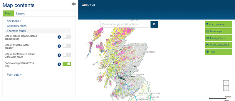
What do I see on my screen?
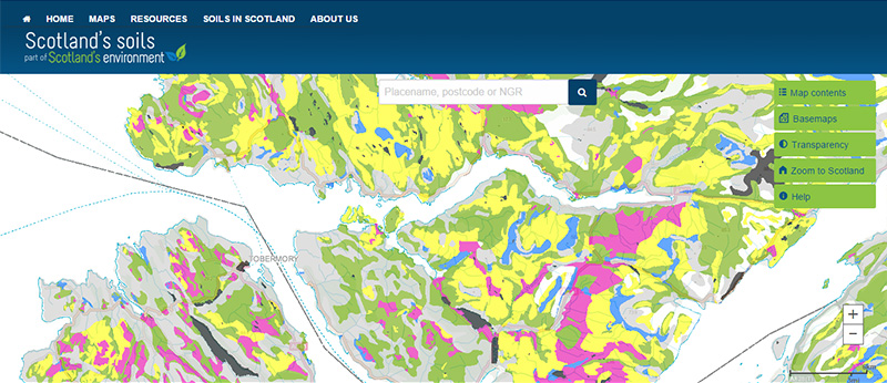
The map shows the distribution of carbon and peatland classes across the whole of Scotland. It gives a value to indicate the likely presence of carbon-rich soils, deep peat and priority peatland habitat for each individually-mapped area, at a coarse scale.
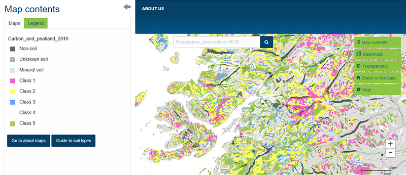
Map legend
The carbon and peatland class is shown in the following categories:
| |
Class description |
Indicative soil |
Indicative vegetation |
 |
Class 1 - Nationally important carbon-rich soils, deep peat and priority peatland habitat. Areas likely to be of high conservation value |
Peat soil |
Peatland |
 |
Class 2 - Nationally important carbon-rich soils, deep peat and priority peatland habitat. Areas of potentially high conservation value and restoration potential |
Peat soil with occasional peaty soil |
Peatland or areas with high potential to be restored to peatland |
 |
Class 3 - Dominant vegetation cover is not priority peatland habitat but is associated with wet and acidic type. Occasional peatland habitats can be found. Most soils are carbon-rich soils, with some areas of deep peat |
Predominantly peaty soil with some peat soil |
Peatland with some heath |
 |
Class 4 - Area unlikely to be associated with peatland habitats or wet and acidic type. Area unlikely to include carbon-rich soils |
Predominantly mineral soil with some peat soil |
Heath with some peatland |
 |
Class 5 - Soil information takes precedence over vegetation data. No peatland habitat recorded. May also include areas of bare soil. Soils are carbon-rich and deep peat. |
Peat soil |
No peatland vegetation |
 |
Mineral soil - Peatland habitats are not typically found on such soils (Class 0) |
Mineral soils |
No peatland vegetation |
 |
Unknown soil type – information to be updated when new data are released (Class -1) |
Not classified (unknown soil type) |
Not applicable |
 |
Non-soil (e.g. loch, built up area, rock and scree) (Class -2) |
No soil |
Not applicable |
What is included in the digital dataset?
The dataset contains carbon and peatland class values, as well as over 439,000 records providing detail on the main soil types and habitat characteristics associated with each area mapped. The full description of this dataset is given in the technical information listed below.
How was the map / dataset created?
The map was created by Scottish Natural Heritage (now NatureScot) and based on James Hutton Institute data providing a consolidated spatial dataset. The dataset combines historical soil information, at the 1:25 000 scale where available, and 1:250 000 scale elsewhere, with land cover from 1988 data. The map also shows areas of peat referred to in the Scottish Planning Policy - carbon-rich soil, deep peat and priority peatland habitat.
How is it updated?
The first map created in 2014 was updated following public consultation in 2016. Future updates may be considered if updated soil and habitats data become available at a national scale.
Using the map
What can I do?
Click on the map, insert a post code or grid reference, to find out the carbon and peatland class. You can also download the map data.
The carbon and peatland class values are recorded in a field attribute called IMPORTANCE.
The map is a high-level planning tool created to promote consistency and clarity in the preparation of spatial frameworks by planning authorities. The map is a predictive tool which provides an indication of the likely presence of peat on each individually-mapped area, at a coarse scale. The types of peat shown on the map are: carbon-rich soils, deep peat and priority peatland habitat.
Be aware: This map is produced at a fixed scale; zooming-in does not change the resolution of the map.
Technical and reference material
Read more about the map at the NatureScot website
This page was last updated on 11 Jul 2023
Adobe Acrobat Reader is the free, trusted leader for reliably viewing, annotating and signing PDFs.
Download Adobe Acrobat Reader